Critical Infrastructure Risk Mapping under Climate Disruptions
Spatial risk modeling framework to identify infrastructure vulnerable to extreme climate events and support resilience planning.
(Balaji, Gina, Sachelle, Theo)
2025 - Present
(ArcGIS, QGIS, Python, Excel)
Research Work - Spatial Analysis | Scenario Mapping | Technical Writting

Summary
New York State’s critical infrastructure,including power, water, telecommunications, and transportation is increasingly exposed to climate-driven disruptions such as flooding, extreme heat, and winter storms. At the same time, infrastructure systems are major contributors to greenhouse gas emissions and air pollution, creating a dual challenge: improving resilience to climate impacts while accelerating decarbonization. These two objectives are often addressed separately, despite their interdependence.
The project integrates infrastructure networks, climate hazard exposure, and emissions data to reveal geographic areas where infrastructure resilience and decarbonization investments can deliver the greatest impact. The analysis supports planners in prioritizing infrastructure modernization strategies that improve system reliability while advancing climate mitigation goals.

Approach
Critical infrastructure systems, including power, water, telecommunications, and transportation—are increasingly exposed to climate hazards such as flooding, extreme weather, and aging system failures. At the same time, these systems contribute significantly to emissions and environmental burden. Planning efforts often address resilience and decarbonization separately, limiting the ability to identify infrastructure investments that achieve both objectives simultaneously.
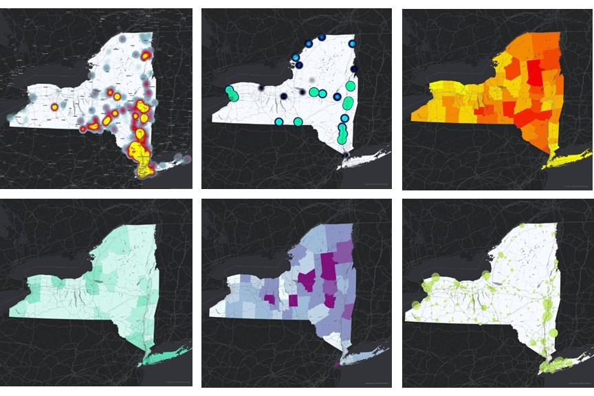
Developed a geospatial decision framework integrating infrastructure networks, climate hazard layers, emissions data, and service reliability indicators. Using ArcGIS and spatial suitability analysis, infrastructure exposure, emissions burden, and service vulnerability were mapped and evaluated to identify regions facing overlapping risks. Multi-layer overlay and spatial classification techniques were used to generate infrastructure vulnerability and investment priority maps across New York State.

Results
The analysis identified spatial clusters where critical infrastructure faces both high climate exposure and elevated emissions burden. Risk mapping revealed geographic disparities in infrastructure vulnerability, particularly in areas with aging infrastructure, high emissions intensity, and increased exposure to climate hazards such as flooding and extreme weather. The framework produced spatial risk maps, emissions exposure maps, and integrated vulnerability indices to support infrastructure investment prioritization.


Impacts
This project provides a decision-support framework for planners and agencies to prioritize infrastructure investments that simultaneously improve climate resilience and reduce emissions. By identifying infrastructure systems and regions facing dual risks, the model enables targeted investment strategies that enhance infrastructure reliability, reduce environmental burden, and support long-term decarbonization goals. The framework is scalable and can support climate resilience planning, infrastructure modernization, and policy development at regional and state levels.
Want to discuss more about
this project ?
